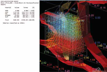
 Depending on the volume of information
incorporated, Vulcan can develop
a block model in
Depending on the volume of information
incorporated, Vulcan can develop
a block model in
minutes, the company
reports. Once a model is generated for
a stope, several reports can
be created
for storing grade block data in output
databases. Reports can be produced
immediately after grade block creation
and customized for managers, metallurgists,
engineers
and geologists,
the company says. (Photo: Maptek)
In an effort to increase productivity, more
miners are turning to orebody modeling
software to generate accurate models,
maps, plans and forecasts. These systems
create 3-D models of orebodies based on
drill hole sampling and other data, which
can impact every downstream process
from planning production to predicting
the changes in head grade for the plant.
Many of todays software and solution
offerings provide accurate, dynamic and
user-friendly orebody and subsurface
mapping. Three of the biggest are discussed
below.
Vulcan Integrates and Optimizes
Last April, Maptek released Vulcan Version
10, which featured a number of new
tools. Those include the Automated Pit
Designer, Data Analyzer, Uniform Conditioning,
Maptek Workbench, Interactive
Block Planner and Split Pit Solids.
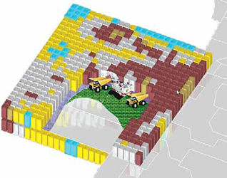
Maptek Vulcan assimilates numerous
and vast datasets to create 3-D, animated,
custom models, on which virtual operations
can be tested. Data sources include
sample data, face mapping, grade
models, reserve reports and plans, assay
and geological data, drilling (exploration
and production), channel and grab samples,
the company reported. A grade
control model is generated in minutes
via an automated specification-driven
process. The grade control model can be
reconciled against the exploration block
model to generate accurate tonnage,
grade and ounces, accurate reserves reports,
profit information.
Dynamic animations enable simple
expression of complex information that
can then be conveyed and used across
an enterprise, Robert Slade, senior vice
president, sales, said. A picture speaks
a thousand words. We can combine all of
the relevant data into one 3-D working
window ... that is not only the data from
the drill holes, he said. It also captures
all of the topography, the current mining
faces. You also have enormous amounts
of data from other pieces of information:
The dump areas, the roads, the accesses.
Where was the face on Friday morning?
Where is it now?
Illustrated working reports for use elsewhere
in the enterprise can be extracted
from the digital mine. Vulcan gives users
the ability to access the model and hover
over any of the drill holes and the data and
to visualize and interrogate. The interpretation
of the blast is very clear in the colored
blocks, which give you the high, low
and waste designation, Slade said. Using
very standard tools, it can give you a reserve
report instantly, which presents the
bench polygons that are sent to the surveyors.
The surveyors go out and indicate
where those polygons are on the blast. Alternatively,
for GPS- and/or Wi-Fi-connected
mines, this information can be instantly
accessed by equipment operators to guide
excavation and material dispatch.
One of Vulcans selling points, Slade
said, is the integration of Exploration to
Scheduling tools in one user-friendly and
powerful interface. Vulcans time-tested
and proven exploration database, CAD,
triangulation and block modeling toolsets
now incorporate productivity and optimization
tools like never before. These include
the latest implementation of the Stope
Optimizer module (Version 3) now incorporating
Risk Analysis, plus 6- and 8-point
stope shape capability, he said. Mine
Planning advancements include the latest
release of Vulcans Gantt Scheduler and
Mapteks Evolution Mine Scheduling suite,
incorporating genetic algorithms and distributed
cloud processing. When it comes
to the toolset integrated and accessible
from the platform, Slade added, Vulcan
has the best in the industry by far.
Take for example, the Vulcan Gantt
Scheduler tool, described by Slade as a
game-changer. Imports and exports are a
thing of the past with our latest integration
developments, he said. The tool features
functionalities offered by Microsoft Project.
And it integrates all the power and
functionality of Vulcans mine design and
modeling capability to deliver animated mining sequences that empower users to
conduct tests, plan operations, hone processes,
and make forecasts, Slade said.
These animations convey more information
than Microsoft Project Gantt charts.
Plus, they are more user-friendly, he said.
Not everyone understands a (Microsoft
Project) Gantt chart. They dont relate
to where your development is at the end of
May, where your stopes have progressed
to at the end of June, Slade said. Where
should we be at any point in time? What
is the amount of metal we are going to
realize from that work? What year is metal
production going to drop and for what reason?
Those sorts of questions can be answered
and illustrated with those animations,
those 3-D moving pictures, which
go beyond a Gantt chart representation.
Maptek reportedly is primed to release
an update to their new Grade Control
package that will enable automated generation
of bench block out polygons.
Our future is the automation and optimization
of polygon shapes that are used to
produce the grade control result, meaning
identifying the tons and grade of each ore
classification, high grade or low grade,
Slade said. Drawing the material destination
shapes by hand is really the only
tedious part of this whole process. A user
has to come in and make that call, iterating
through multiple combinations. What
if they could hit a button and then that
line would automatically pull out exactly
the optimum line or shape?
Slade said Vulcan can give a miner
a competitive advantage in a period of
general uncertainty within the sector. He
pointed to Lundin Minings Eagle mine in
Michigan, for example, which deployed
Vulcan in 2014. [It] is being used by all
technical services departments including
engineering and geology, the miner
told Forge, Mapteks technical magazine.
The mine needed to produce an on-the fly block model outlining higher grade
zones as well as lithology changes within
a single stope. Engineers also wanted to
determine mineable stope shapes based
on current metal prices.
Lundin was motivated by the same
economic forces that are compelling other
miners to adopt state-of-the-art geology,
grade control and mine planning software
packages, Slade said. Mining has become
marginal over the past decade. Its been
difficult. Prices have been low. Capital is
hard to find, he said. However, it is also
a good time because it puts pressure on
everyone to do things better and faster.
MineSight Empowers
Acquired by Hexagon in 2014, geology
and mine planning software platform MineSight
made headlines last August with
the latest release of MineSight Planning
Suite Version 9.6, which the company said
featured improvements to the MineSight
Schedule Optimizer (MSSO) software.
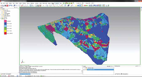
 Minesights grade control solutions simplify the acquisition of information for
cut planning and daily reporting, the
company reports. MineSight has
comprehensive reserve and modeling utilities that are integrated throughout all
of our planning tools, Seth Gering, software quality assurance engineer, says.
This means that MineSight users
can use the same resource estimation
methodology and data for all parts of the planning and grade control process
without having to manually transfer data between projects. (Graphic: Hexagon)
With the update, the company reported,
MSSO now provides a complete
planning, operations and safety workflow.
It fully supports stratigraphic models,
also known as Gridded Seam Models.
Mining geometries [polygones or solids]
can be imported into MSSO either from
MineSight 3D viewer or from an existing
MineSight Planner project, Hexagon reported.
Through integration with Mine-
Sight Reserve, reserves associated with
the geometries along with a list of mining
seams available in the GSM are used for
proper reserve allocation.
The version features cashflow constraints,
allowing you to define cashflow
limits, Hexagon said. It also allows for
customized benching with options for defining elevation range for polygonal geometries.
Other highlights include advanced
constraints relaxation; fixed cost by phase
and destination; ability to export cut geometry
to MineSight 3D (MS3D) objects
and MS3D End-of-Period tool; and speed
improvements for reserve calculation.
This and an optimization tool for stope
design to be released in the near future
will bring together powerful visualization,
modeling, scheduling and reconciliation
all into one single user environment,
Seth Gering, product manager,
operational planning, said. We are looking
forward to improving workflow.
Simplified, MineSight, like its competition,
is a cyber hub, a platform that
enables distant users to operate in a centralized
location, and to deploy a software
suite to manage data and generate a 3-D
digital twin of a mine. What separates it
from the competition, Gering said, is its
dynamism. Our clients are collecting information
to make better decisions using a
variety of different systems, so our tools allow
users to connect to virtually any source
through a configurable interface, he said.
For example, we had one client that had
spent a lot of time building and populating
a fragmentation database and wanted
to use that information coupled with their
grade control system for data analysis and
making better decisions. This was not a problem because we could easily connect
to assay, geology, survey or other systems
through the configurable interface.
MineSight facilitates information-sharing
and collaboration. Although most systems
are now SQL or API based, there are
many that still require ASCII or DXF for
data transfer. Our solution is easily configurable and scalable so that operations
can share information using any format
they have today and in the future, Gering
said. We often implement grade control
systems during the early stages of the
mining process when not all Fleet Management
Systems (FMS) or other systems
are in place. However, because our system
is configurable, we can easily incorporate
new systems in the grade control workflow
as they are implemented or come online.
The savings are real, he said. Information
and data-sharing enables engineers
to spend less time manually transferring
data. Ive seen sites where users are
manually copying tonnages, grade, and
plant information or using a variety of
Excel sheets and csv files, Gering said.
This takes time and could compromise
data integrity. Engineers should be spending
time analyzing data and improving
processes instead of copying data manually.
Consider for example, Gering said,
one operation that was spending more
than 20 hours per week manually transferring
data between planning, assay and
FMS. With MineSight, they were able
to integrate information from fragmentation,
planning, drill and blast, and FMS
sources that both reduced staff downtime
and increased truck load/dump cycles by
about 13% or 100 trucks per day.
A U.S. mine that implemented Mine-
Sight-optimized grade control and drill and
blast systems arrived at an innovative grade
control workflow that was presented at our
annual MineQuest conference and resulted
in a 12% cost savings for the drill and blast
teams, Gering said. All of this was done
by the users themselves and reinforces our
goals for making tools that are easy to use
and easy to implement. Therein lies the
utility of the platform. It empowers users to
gain control of their workflows and to make
them faster, easier and safer, he said.
MSSO continues to add value to the mine
planning workflow in many areas.
Dassault Offers Virtual Reality
Centered on geology and grade control,
Surpac is one of Dassault Systèmes mine
planning software applications offered under
its Geovia brand, which also includes
GEMS, a geology and mining collaborative
system engineered to support cross-functional
teams within an enterprise.
 Surpac, geology and mine planning software under the Geovia brand, is slated for two updates in 2017, Andy Mulholland,
Dassault Systèmes, portfolio management director,
says. The future for GEOVIA in mining centers on the Dassault Systèmes
3DEXPERIENCE platform, a unique business platform delivered both on-cloud and on-premises, and
which will facilitate
collaboration and integration across the entire mine value chain. (Photo: Dassault Systèmes)
At the core of Dassault Systèmes offerings
is the 3DEXPERIENCE Platform,
described as a business experience
platform, which the company reported
in September had reached its 10,000th
production user. Nicolas Jeannée, senior
manager, natural resources industry
solution experience, said the platform,
which serves as a cyber hub and can be
premises- or cloud-based, enables users
at disparate locations to access a single
version of the truth.
The platform is really about technical
collaboration, data management and continuous
innovation he said. Being able
to ensure you are centralizing and sharing
data that are reliable and up-to-date is a
key expectation of mining companies, and
this is something we are providing through
the 3DEXPERIENCE Platform.
The platform facilitates fluid navigation
to the apps, including social and collaborative
apps, intelligence apps, simulation
apps and 3-D modeling apps, like
Surpac. The company described Surpac
as the worlds most popular geology and
mine planning software, which delivers
efficiency and accuracy through ease-of-use, powerful 3-D graphics, and workflow
automation that can be aligned to company-
specific processes and data flows.
Drilling data, as well as performance
data captured by the equipment, is assimilated
and managed by the 3DEXPERIENCE
Platform. Like its competition,
Surpac reconciles drill hole and sampling
data with virtual mine models, and can
create user-friendly, 3-D graphics, to include
short-term block models that are
data-rich, colorful and scalable. These
models are further informed by data from
mines all over the world to ensure a grade
control framework that provides a clear understanding
of grade variations, and allows
for improved decision making to drive profitability,
the company reported.
GEOVIA technology allows users to
import data from various sources, manage
survey station data and interface
with data collectors, Andy Mulholland,
portfolio management director, said. Selecting
from a variety of instrument types
and reduction techniques, surveyors can
establish profiles to streamline the data
entry process or download measurements
directly from total stations and GPS recorders,
he said. Triangulated surfaces
can be created from status maps and
then used to determine volumes moved
between two or more working periods.
Data can also be used directly from other
formats with the data plug-ins module.
Geovia software is the recognized
world leader of integrated geology and
mine planning solutions, Mulholland
said. MineSched delivers interoperability
through integration with every major
geology and mine planning software package
on the market.
InSite integrates
with almost any data source, providing
a single view of the truth with a holistic
view of the operations from pit to port.
Make that virtual pit to port. Dassault
Systèmes announced January 5 that
3DEXPERIENCE Platform users can now
view, explore and validate product designs
in immersive virtual reality at any stage of
the product development process with support
from the HTC Vive Business Edition
virtual reality system. Users don a headset
and work at their desktop, from which
they can access, view and explore a native
virtual model, giving an enhanced spatial
impression for a deeper understanding
of an objects depth, solidness and design
that cannot be achieved with a computer
screen alone, the company reported.
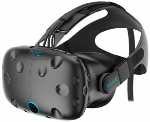 The HTC Vive Business Edition headset enables 3DEXPERIENCE Platform users
to plug and play an HTC Vive
Business Edition head-mounted display and work
at their desktop with natural navigation in a stereoscopic virtual
reality environment,
Dassault Systèmes reports. (Photo: HTC)
Broken down, this means a decentralized
enterprise can operate out of a centralized
cyber hub, the 3DEXPERIENCE
Mine, and use a common software suite
to shape its digital twin, which can now
live in a virtual reality environment. In
short, miners can shape a digital mine so
real they can virtually blast it.
The concept of a digital twin is a true
singularity whose significance has been
marginalized in the ceaseless eruption of
high-tech innovations comprising the ongoing
space age revolution. Its conceptual
predecessor is the legal entity, defined
by Blacks Law as an entity, other than
a natural person, who has sufficient existence
in legal contemplation that it can
function legally, be sued or sue, and make
decisions through agents as in the case
of corporations. Whereas maritime law
birthed the legal entity, big data birthed
the digital twin, a dynamic but defined
cyber entity, be it a person or a company,
with sensor and sampling data instead
of blood, and pixels instead of skin cells.
Users can operate and experiment on it.
From it they can extrapolate and forecast.
If the digital twin is the logical outcome
of the rise of the Internet of Things
(IoT) and the resulting deluge of data that
has purged mining of guesswork and estimates,
then the 3DEXPERIENCE Mine is
the ark for plying those waters, Jeannée
said. Mining companies are facing larger
and large databases all the time, he
said. We are talking about big data and
IoT. That is why it is crucial to leverage all
this data together using a single appropriate
framework. That is the idea of the
3DEXPERIENCE Mine.
Three updates to the Geovia brand
in 2017 are expected, Mulholland said.
GEOVIA is introducing a new cloud-based
next-generation rapid geological modeling
capability, to be delivered under an innovative
SaaS (Software-as-as-Service)
model on the 3DEXPERIENCE platform
and seamlessly integrated to GEOVIAs
desktop applications, he said. Additionally,
2017 will see the introduction of
advanced point cloud technology into Surpac
for processing and utilizing the vast
amount of scanning information available
from unmanned aerial vehicle drone surveys
and vehicle mounted underground
survey equipment. Also coming in 2017
is a new algorithm for GEOVIA Whittle that
greatly reduces the time taken to develop
a strategic mine plan thus allowing input
sensitivity analyses to be completed in
rapid succession giving the mine planner
a readymade library of off-the-shelf plans
that can be used as and when the operating
environment changes.
As featured in Womp 2017 Vol 02 - www.womp-int.com